Where our more in depth weather journey begins.
The bare basics of weather can be explained using the bathroom and kitchen! Take the humble kettle. As the water in it heats, steam rises from it. What is steam and why does it rise in this case?
Steam is actually water vapour that has condensed into tiny droplets as it cools. (Exactly how clouds form!). It rises as it is more buoyant than the surrounding air. Take a foam ball and push it under water in the bath then let it go. It rises to the water surface yeah? Because it is more buoyant (less dense) than the surrounding water.
Getting back to our kettle steam, this process of rising due to buoyancy caused by heat is called convection. If the kitchen had no roof, the steam would rise to a height where it’s buoyancy equals that of the surrounding air, or reached a pocket of cooler, denser air(this actually happens sometimes in the atmosphere but more on that later).
One very important point in all of this is that the air temperature normally decreases by 2 degrees Celsius for every 1000ft you go up. This is called the Environmental Lapse Rate (ELR). If the ELR is greater than 2C/1000ft, rising warm air will move quicker and higher.
Now for the bathroom. With the shower running, the room will fill up with steam (without an exhaust fan). This steam is the same as cloud as discussed above. Fog is just cloud at ground level! If the steam touches a colder surface like a mirror, it condenses into water droplets (Mirror fogs up and water runs down).
Adiabatic Heating and Cooling
If we take a parcel of air and compress it by putting it under pressure, it heats up. Take a bike pump. Have you ever touched the nozzle of a bike pump after pumping up a ball? Burnt fingers right? This process of a gas heating under pressure is called ADIABATIC HEATING – no heat is added from an external source.
What if the opposite were to happen; a gas was allowed to expand? The gas would cool. This is the basic principle behind refrigeration – compressed gas is allowed to expand thus dropping in temperature. You might ask what has all this got to do with weather? These adiabatic processes lead to the formation of frost, hail and even clouds themselves.
As a parcel of air rises in the atmosphere it encounters less pressure, so expands and cools. The rate of cooling is 3°C per 1000ft and is called the DRY ADIABATIC LAPSE RATE(DALR). DALR is fairly constant from day to day and place to place. If the rising parcel of air is relatively humid and cloud forms, the lapse rate changes through the now saturated air. This SATURATED ADIABATIC LAPSE RATE (SALR) is 1.5°C / 1000ft.
These concepts and changes of state (next topic) are crucial for understanding what happens in storm clouds and clouds generally.
Changes of STATE
For water vapour to condense to water drops (like dew on the grass), it must lose heat. For dew drops to freeze into frost they must lose more heat.
For frost to melt and dew drops evaporate, they must ABSORB heat.
This is what happens in clouds and the formation of clouds. In a storm, the heat released by condensation of water vapour adds to the energy available to the storm ( ie: energy of the updraught).
Atmospheric Stability and Lapse Rates
Vertical wind shear is a change in wind direction with upward or downward change in altitude. Horizontal wind shear is a change in wind speed with change in altitude.
As we go up from sea level, the air temperature will drop by 3c per every 1000ft. This is known as the DRY ADIABATIC LAPSE RATE(DALR). If this lapse rate were to increase to say 6c/1000ft, a warm parcel of air is going to become buoyant very quickly and therefore will quickly rise to a level of matching air pressure. What if that level were to be 30000ft and the parcel of air were to be very moist? This is how storms develop. If the rising parcel of air encounters horizontal wind shear, any clouds will show an apparent lean (you all would have seen that). If the parcel of air encounters vertical wind shear as it rises, the column will start to spin around a vertical axis.
Layers of the Atmosphere and Cloud Types.
The Atmosphere has 5 basic layers. From the ground up they are: Troposphere, Stratosphere, Mesosphere, Thermosphere and Exosphere.
Our weather is mainly in the Troposphere which extends up to around 65000 ft above the equator. In our neck of the woods, it usually extends up to around 33000-36000ft. The boundary between the Troposphere and Stratosphere is called the Tropopause indicated by the top of a mature storm’s anvil. One important point about the Tropopause is that it is also the boundary between negative and positive ELRs. Positive lapse rates being above the Tropopause. The Stratosphere can affect more long term weather patterns. The other layers do not affect our weather and will not be discussed here.
Cloud Types.
There are 3 general categories of clouds based on altitude:
Strato – close to the ground (up to around 12000ft) or clouds in flat layers
Alto – mid level (12000 – 20000ft) Can be layered (strato) or heaped (cumulo or Cumulus)
Cirro – high level (20000 to 65000ft) Can be layered or cumulo. Clouds above around 30000ft totally consist of ice crystals.
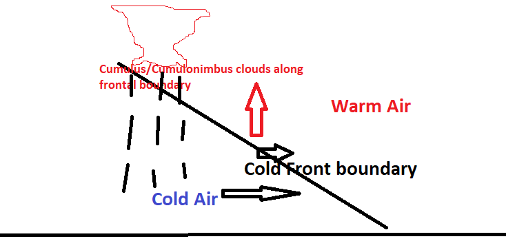
Cold Fronts
Where an area of cold air pushes under relatively warmer air, the warmer air is forced to rise much quicker than normal. This forms a line of cumulus/storm clouds along the frontal boundary.
Rain
Rain forms when droplets of water vapour condense and get too big to be held in the cloud-so falls as rain. Rain is measured in mm, so 1mm of rain is the amount of rain to cover one square meter to a depth of 1mm. As the air gets warmer it can hold more water vapour so the potential amount of rain to fall increases.
If a cold front pushes through as described above, the air cools so water vapour condenses and falls as rain. In storms, the water droplets can be repeatedly pushed up in the updraught, collect more water and eventually fall as larger rain drops-or hail if frozen.
Thunderstorms
Storms need 3 basic ingredients to form; heat, moisture and something to force air to rise (instability)
Heat
Heat comes from solar radiation and/or warm air coming from somewhere else (in southern Australia it could be northerly winds).
Moisture.
comes from humid air which again can often come from somewhere else (pushed south from the tropics in southern Australia).
Instability.
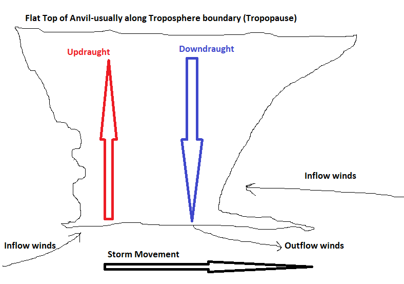
This can come from a cold front (cold air pushing warm air aloft quicker than normal) or a convergance line(a boundary of meeting air currents from different directions-usually a trough line). Below is a diagram of basic storm structure:
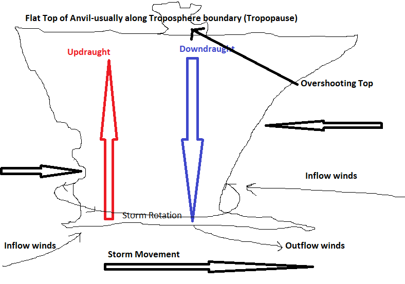
Obviously from the above diagram, if the up and down draughts are separate, the storm can continue to evolve. If the updraught is powerful enough it will punch through the tropopause to form an Overshooting Top.
At this point it is classified as a severe storm due to it's strength and the likelihood of large hail. If the updraught encounters winds from different directions as it rises, it can start spinning around its vertical axis, causing the whole storm to rotate.
The storm is now a SUPERCELL-the most dangerous type of storm! Producing heavy rain, large hail and even tornados. They can last for hours and travel hundreds of kilometers! See below diagram:
Identifying a Supercell.
Supercells can be identified by the following characteristics:
-
They appear round like an SPC fruit can
-
They have horizontal ridges of cloud protruding from the main storm as bands around the storm, giving a laminar appearance.
-
Whole storm is rotating about a vertical axis
-
They move in a different direction to other clouds.
-
They move against the strong surface wind.
-
They can have a long thin line of cloud ("Beaver Tail") extending out from the storm base.
-
Parts of the cloud beneath the storm have a bluey green tinge indicating large hail
-
The front of the storm (in direction of movement) has a protruding wedge of cloud at the base (Shelf cloud).
A dying supercell above with distinctive wall cloud underneath and "beaver tail" to the right. Note also the circular shape of the cell in above and below pics-indicative of the whole thing rotating!
For those familiar with watching the radar when storms are around, Supercells can have a particular identifying signature called a "V Notch". This forms when the power of the updraught forces the downdraught to partially split around it, creating a V shape on the radar; often with a black core at the apex as shown in the two radar frames below(courtesy of the BoM).
Lightning & Electric Charge in a storm
A thunderstorm is a very turbulent place with air flowing in multiple directions and speeds. Therefore water droplets and ice crystals collide stripping off electrons. These electrons accumulate along the base of the storm as a negative charge. Similarly positive charge accumulates in the top of the storm and on the ground-as shown in the diagram.
If the difference in charge is strong enough to break down the insulation of the air, a lightning spark will form. As seen in the diagram, it can be cloud to cloud or cloud to ground. The principle is the same as being zapped on a door knob or lift button-just on a different scale!
As mentioned in my audio titbit on thunderstorms, the lightning heats the air to temperatures hotter than the suns surface. This sudden expansion of the air creates massive air pressure waves that move out from the lightning bolt-that we hear as thunder.
Lightning will usually strike the tallest object-but not always! If you are outside during a storm and you feel your hair standing on end-immediately drop to the ground and roll into a ball-you could be about to be struck by lightning!! The storm may not necessarily be overhead either!
NEVER SHELTER UNDER A TREE!